
Most hikers quit before January. That’s their loss.
South Korea’s mountains don’t shut down in winter — they transform. The trails that draw millions during autumn foliage season become something else entirely once the first snow falls: quieter, sharper, and brutally honest about who belongs there. A ridge that took three hours in October might take five in February. The reward scales accordingly.
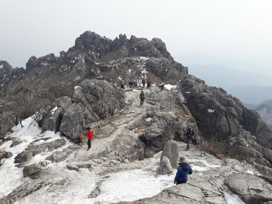
Winter hiking in Korea is not a niche pursuit for extremists. It is, by any honest measure, the most visually concentrated hiking experience the peninsula has to offer. Snow-capped peaks, frozen waterfalls, and pine branches bent low under the weight of white — these are not postcard fabrications. They are Tuesday mornings on Seoraksan (설악산) if you leave the trailhead before 6 a.m.
Why Winter? Because Everyone Else Has Already Left
Korean national parks collectively recorded over 44 million visitors in 2022, according to the Korea National Park Service. The bulk of that traffic concentrates between late September and early November. By December, the crowds thin to a fraction. By January, you may walk an entire ridge trail and count the other hikers on one hand.
That silence has weight. On a snow-covered trail above 1,000 meters, the only sounds are your own breathing and the occasional crack of ice-laden branches. No vendor stalls. No tour group commentary echoing off granite walls. Just the mountain doing what mountains do when humans stop interrupting.
This is not a coincidence of geography. It is a consequence of perception. Most visitors — domestic and foreign alike — treat Korean mountains as fair-weather destinations. Winter reveals what they’re actually made of.
The Mountains That Earn Their Reputation in Snow
Three peaks define the Korean winter hiking conversation. Each offers a different relationship with cold, altitude, and effort.
Seoraksan, straddling the northeastern edge of Gangwon Province, reaches its highest point at Daecheongbong (1,708 meters). In January, summit temperatures regularly plunge to -15°C or lower — roughly the same range as a mild day in Reykjavik. The Osaek (오색) trail and the Biseondae (비선대) route both offer dramatic winter scenery without requiring technical climbing gear, though microspikes are non-negotiable above 800 meters.
Jirisan (지리산), the largest national park by area on the Korean mainland, sprawls across three provinces. Its Nogodan (노고단) ridge, accessible from Seongsamjae (성삼재), is one of the few high-altitude areas in Korea where a reasonably fit hiker can reach a snow-covered plateau within 90 minutes of the parking lot. At 1,507 meters, Nogodan delivers panoramic views across a sea of white-capped ridgelines stretching toward the horizon in every direction.
Hallasan (한라산), the dormant volcano at the center of Jeju Island, stands at 1,947 meters — the highest point in South Korea. In winter, the summit trail via the Gwaneumsa route becomes a full-day technical undertaking. The mountain receives heavy snowfall from December through February, and the Korea Meteorological Administration has recorded wind speeds exceeding 30 m/s near the crater rim during winter storms. Hallasan does not negotiate.
📍 Seoraksan National Park (설악산국립공원)
- Address: 833 Seoraksan-ro, Sokcho-si, Gangwon-do
- Hours: Varies by season and trail; main entrance opens at 04:00 in summer, with restricted hours in winter — check ahead
- Admission: KRW 3,500 (adults)
- Getting there: Express bus from Seoul Dong Seoul Terminal to Sokcho (approx. 2.5 hrs), then local bus No. 7 or 7-1 to the park entrance
- Official site: https://seorak.knps.or.kr
📍 Jirisan National Park (지리산국립공원)
- Address: 78 Jirisan-ro, Hamyang-gun, Gyeongsangnam-do (Hamyang entrance)
- Hours: Trail access hours vary by route and season
- Admission: Free
- Getting there: Bus from Namwon or Gurye to respective trailheads; Seongsamjae accessible by taxi from Gurye
- Official site: https://jiri.knps.or.kr
📍 Hallasan National Park (한라산국립공원)
- Address: 1100-ro, Jeju-si, Jeju-do
- Hours: Entry cutoff times strictly enforced; Gwaneumsa route entry closes at 12:00 in winter
- Admission: Free
- Getting there: Rental car or taxi from Jeju City; no direct public bus to the Gwaneumsa trailhead
- Official site: https://hallasan.go.kr
What the Trail Actually Demands
Foreign hikers consistently underestimate Korean winter trails in two specific ways. First, they arrive in trail runners. Second, they assume the trail markers will be visible beneath the snow. Both assumptions are costly.
Korean national parks enforce mandatory equipment checks at certain trailheads during winter months. Rangers stationed at entry points will turn back hikers wearing inadequate footwear — and they do. This is not bureaucratic theater. It is a response to a documented pattern of rescue operations triggered by unprepared visitors. The Korea Mountain Rescue Service responded to over 8,700 mountain accidents in 2021, with a disproportionate share occurring in winter.
The minimum kit for any Korean mountain above 1,000 meters in winter: microspikes or crampons, trekking poles, a thermal base layer, a wind-resistant outer shell, and a headlamp. Not because the trails are technically extreme — most are not — but because conditions can shift within a single hour. A clear ridge at noon can become a whiteout by 2 p.m. on Seoraksan’s upper slopes.
The Scenario No Travel Blog Prepares You For
You’re descending the Osaek trail on Seoraksan at 3:30 p.m. in late January. The light is already failing — at this latitude, winter sunset arrives before 5:30 p.m. Your left knee is protesting the downhill grade. The trail markers, orange rectangles nailed to trees, are partially obscured by accumulated snow. Your phone shows 12% battery. You haven’t seen another hiker in 40 minutes.
This is not a crisis. It becomes one if you haven’t prepared for it.
The practical response: download the Naver Map app with offline trail data before leaving your accommodation. Carry a portable battery. Know the park’s emergency number — 119 covers mountain rescue across Korea — and have your trailhead’s name in Korean ready to communicate. Rangers respond faster when you can confirm your location. The nearest hospital to Seoraksan’s main entrance is Sokcho Medical Center (속초의료원), approximately 15 minutes by car from the park entrance. If you’re hiking solo in winter, leave your trailhead name, intended route, and expected return time at your guesthouse front desk. Not as a formality. As a practical safeguard.
Worried about the language barrier at the trailhead? Most major national park ranger stations now have staff with basic English. Most also carry printed English-language trail maps available on request. Ask before assuming otherwise.
📍 Sokcho Medical Center (속초의료원)
- Address: 60 Cheongho-ro, Sokcho-si, Gangwon-do
- Hours: 24-hour emergency department
- Getting there: Approximately 15 minutes by car from Seoraksan main entrance
The Smaller Mountains Nobody Mentions
The three flagship peaks absorb most of the conversation. Meanwhile, a second tier of mountains delivers equally compelling winter scenery without the logistical weight.
Odaesan (오대산) in Gangwon Province rises to 1,563 meters and receives some of the heaviest snowfall of any inland mountain in Korea. The Woljeongsa (월정사) temple approach — a one-kilometer forest path lined with ancient fir trees — is among the most photographed winter scenes in the country. Some of these trees exceed 500 years in age, their horizontal branches collecting snow in formations that architectural photographers spend days trying to replicate artificially.
Gyeryongsan (계룡산) near Daejeon offers a more accessible winter option for visitors based in central Korea. At 845 meters, it demands far less physical commitment than the northern peaks, but its granite ridgelines and Buddhist temple complexes — particularly Magoksa (마곡사), a UNESCO World Heritage Site — deliver a concentrated dose of Korean mountain culture within two hours of Seoul by KTX.
📍 Odaesan National Park (오대산국립공원)
- Address: 374-8 Odaesan-ro, Jinbu-myeon, Pyeongchang-gun, Gangwon-do
- Hours: Trail access varies by season
- Admission: Free (Woljeongsa temple entrance fee applies separately)
- Getting there: Book tours in advance or take the bus from Jinbu intercity bus terminal to Woljeongsa; Jinbu is accessible by KTX from Seoul (approx. 1 hr 20 min)
- Official site: https://odae.knps.or.kr
What You Eat When the Mountain Is Done With You
Post-hike culture in Korea is inseparable from the trail experience. At the base of virtually every major trailhead, a cluster of small restaurants serves a version of the same menu: sundubu jjigae (순두부찌개, soft tofu stew), doenjang jjigae (된장찌개, fermented soybean paste stew), and makgeolli (막걸리, unfiltered rice wine). These are not tourist concessions. They are functional recovery meals that Koreans have been eating after mountain descents for generations.
The logic is caloric and thermal. A bowl of sundubu jjigae arrives at the table still boiling, loaded with soft tofu, vegetables, and egg, delivering roughly 250–350 kcal in a format that reheats a cold body faster than any energy bar. The stay connected makgeolli — slightly sweet, slightly sour, around 6–8% alcohol — has been the hiker’s drink of choice on Korean mountains since the Joseon Dynasty. Order it cold. It arrives in a metal bowl. This is correct.
The mountain takes everything you brought. The meal at the bottom gives some of it back.
The Honest Cost of Getting It Wrong
Winter hiking in Korea is accessible. It is not forgiving. The distinction matters.
The trails are well-marked, the park infrastructure is excellent, and the rescue services are professional and fast. None of that changes the physics of a 1,700-meter summit in January. Hypothermia onset at altitude in wet conditions can begin within 30 minutes of stopping movement. A twisted ankle on an icy descent four kilometers from the trailhead is a fundamentally different problem in winter than in summer. The margin for error compresses with the temperature.
Foreign visitors who have only hiked in temperate climates sometimes treat Korean winter mountains as an aesthetic backdrop rather than a physical environment with real consequences. The mountains are indifferent to that framing. They were here before the Instagram account and they will be here long after it.
Go prepared. Go early. Go in layers. The rest the mountain handles.
Rover’s Take
Korea built some of the world’s most efficient trail infrastructure, trained rangers who will physically block you from entering unprepared, and still manages to rescue thousands of people every winter — which tells you everything you need to know about the gap between knowing what to do and actually doing it.